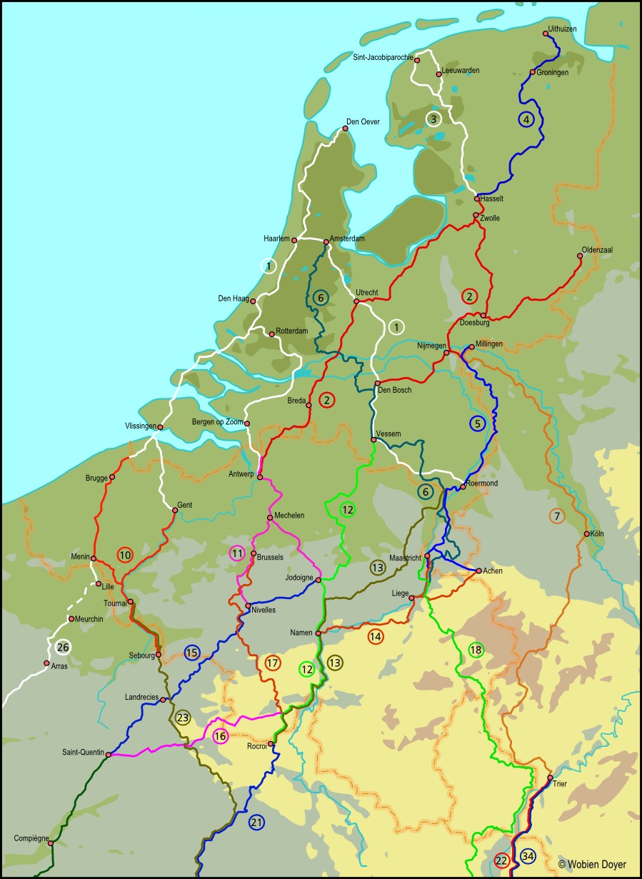
Jacobswegen in Nederland Part 1 West; 1st edition 2011; In Dutch;
Nederlands Genootschap van Sint Jacob, Bram van der Wees a.o.
ISB 978-90-808567-3-8
a: Den Oever - Haarlem - Amsterdam - Utrecht - Den Bosch - Postel or Roermond.
b: Haarlem - Den Haag - Vlissingen - Brugge or Gent.
c: Schipluiden - Dordrecht - Bergen op Zoom - Antwerp.
Van Wad tot IJ; 1st edition 2007; In Dutch; Jan Louter.;
ISBN 978-90-808567-4-5
Wieringen - Haarlem - Amsterdam
Camino des Pays-Bas; In Dutch; Edition Visioned 2009
Haarlem - Schiedam.
Back to top
Jacobswegen in Nederland Part 2 East; In Dutch; 1st edition 2011;
Nederlands Genootschap van Sint Jacob, Bram van der Wees a.o.
ISBN 978-90-808567-5-2
a: Hasselt - Utrecht - Breda - Antwerp,
b: Hasselt - Doesburg - Nijmegen
(connection to Millingen on Jacobspad Limburg) - Den Bosch
c: Oldenzaal - Enschede - Doesburg.
Back to top
Het Jabikspaad; In Dutch; 6th edition 2012; Friese Pers - Noordhoek;
ISBN 90-3301163-8; Jacobiparochie - Hasselt
Back to top
Het Jacobspad Groningen; In Dutch; 1st edition 2008; Stichting Jacobspad Groningen - Drenthe;
ISBN 978-90-813134-1-4; Uithuizen - Hasselt
Back to top
Jacobspad Limburg Tussen Rijn en Maas part 3; In Dutch; 1st edition 2004;
Annette Heusch-Altenstein a.o; ISBN 978-3-7616-1674-1
Millingen - Venlo - Roermond - Thorn - Maastricht - Eijsden
The German version of this guide is more recent than the Dutch version:
Jakobswege band 3; Bachem verlag; 2nd edition 2008;
ISBN 978-3-7616-1673-4
Jacobsweg Rhein-Maas-Weg; In German; Uwe Ziebold, Conrad Stein Verlag;
1st edition 2008; ISBN 978-3-86686-225-8
Millingen - Gogh - Roermond - Eijsden - Liege
Back to top
Pelgrimspad part 1; in Dutch; 4th edition 2010; ISBN 978-90-71068-83-6;
and part 2; 3rd edition 2008; ISBN 978-90-71068-76-8; Wandelplatform LAW;
Amsterdam - Den Bosch - Visé
Back to top
Nijmegen - Köln - Trier
Jakobswege Band 4, Nijmegen-Köln; In German;
Annette Heusch-Altenstein; Bachem Verlag;
ISBN 978-3-7616-2191-2
Nijmegen - Kleve - Xanten - Köln
Jakobswege Band 2, Köln-Trier; In German;
Karlhein Flinspach and Annette Heusch-Altenstein;
Bachem Verlag;
ISBN 978-3-7616-2443-2;
Köln - Kronenburg - Echternach - Trier - Schengen
Via Coloniensis; In German; Ingrid Retterath; Conrad Stein Verlag; 1st edition 2014; ISBN 978-3-86686-241-8
Köln - Trier
Back to top
Still available:
Via Brugensis and Via Scaldea; 1st edition 2010; In Dutch; Vlaams Compostelagenootschap;
ISBN 978-90-812264-2-4
a: Sluis - Brugge - Sebourg (Brugensis)
b: Gent - Sebourg (Scaldea)
There is a new version (partly not yet available). It is now split up in
two guides: Via Scaldea and Via Brugensis Both contain a longer
route than the old one.
Via Scaldea 2nd edition 2016; In Dutch; Vlaams Compostelagenootschap;
Just published! This guide contains both the branch of route 10 via Gent
as route 23. 2 books, one with maps and one with text.
Vlissingen - Breskens - Gent - Tournai - Maroilles - Château-Porcien - Reims
Via Brugensis 2nd edition 2016; Vlaams Compostelagenootschap;
Will be published soon.. It will contain both the branch of route 10 via
Brugge as route 26 until Amiens.
Back to top
Via Brabantica en Via Gallia Belgica; 2nd edition 2015; In Dutch; Vlaams Compostelagenootschap;
ISBN 978-90-821436-14
This guide contains both the Via Brabantica (route 11) and the Via Gallia Belgica
(route15) in two books, one with maps and one with tekst.
Bergen op Zoom or Breda - Antwerp - Jodoigne or Nivelles
and Nivelles - Maubeuge - St. Quentin.
Back to top
Via Monastica; 2nd
edition 2010; In Dutch; Vlaams Compostelagenootschap; ISBN 978-90-812264-62
Vessem - Postel - Jodoigne - Namur - Givet - Olloy-sur-Viron - Rocroi
Back to top
Via Limburgia; 1st edition 2010; In Dutch; Vlaams Compostelagenootschap;
ISBN 978-90-812264-4-8
Thorn - Tongeren - Eghezée - Namur - Givet - Rocroi
Back to top
Via Mosana; in French; 2nd edition 2007; Association Belge des Amis de
Saint Jacques de Compostelle
Aachen or Maastricht - Liege - Hoei - Namur
De weg van de Maasvallei, vertaling Via Mosana; Henk van Gaal
translation Via Mosana into Dutch;
Henk van Gaal
(no maps or hostels)
Jacobsweg Belgien: Achen - Brûly; in German Conrad Stein Outdoor 139;
1st edition 2004; ISBN 978-3-89392-539-1;
Aachen - Liege - Namur - Brûly (Boundary Belgium and France)
Back to top
Via Gallia Belgica; in French; 1st edition 1999; Association Belge des
Amis de Saint Jacques de Compostelle
Hélécine - Jodoigne - Nivelles - Maubeuge - St.Quentin
Via Brabantica en Via Gallia Belgica; in Dutch; 2nd edition 2015; Vlaams Compostelagenootschap;
This new version contains both the Via Brabantica (route 11) and the Via Gallia
Belgica (route 15). See route 11.
GR 655: Sentier vers Saint-Jacques-de-Compostelle: Bruxelles-Paris-Tours; in French; FFRP topo guide ref 6551;
1st edition 2013;
This a GR, that from time to time makes big detours compared to other guides on the same trajects.
Between Brussels and Tours the differences add up to hundreds of kilometers! Very often
beautifull kilometers, the makers of the GR’s rather make
beautifull routes than short routes!
Brussels - Saint-Quentin - Compiègne - Paris - Chartres - Tours or
Paris - Orléans - Tours
Back to top
Via Thiérache; in Franch; 2nd edition 2008;
Association Belge des Amis de Saint Jacques de Compostelle
Olloy-sur-Viroin - Chimay - Guise - St.Quentin
Back to top
The GR 12 runs from Amsterdam to Paris.
The Dutch part is formed by the Floris V pad (LAW 1-3)
Amsterdam - Bergen-op-Zoom, then follows a Flemish and a Wallon part
that both are described in a guide. There is no guide to the French part,
but part of it is described in the Topo Guide Les GR de Picardie.
Only the Wallon part is drawn on the map,
because it can be used as a connection between the routes 11 and 21 :
GR12 Bruxelles - frontiere francaise SGR 4;
In French; edition 2009
ISBN 978-2-930488-10-3
Back to top
The GR 5 runs from the North sea to the French Riviera.
Only the part from Maastricht to Geneva is drawn on the map.
This can be used to connect routes 5 and 6 to routes 22, 34 and 35:
Mer du Nord - Méditerranée - Tronçon Wallonie et
Grand-duché de Luxembourg; GR 5; in French; Henri Corne a.o.;
Liège : Les Sentiers de Grande Randonnée; edition
2009; ISBN 978-2-930488-08-0;
Maastricht - Liege - Spa - Ouren - Diekirch
Trekking in the Vosges and Jura and other walks; In English;
Along GR 5 and GR 53 from the French-Luxemburg boundery to lake Geneva;
Cicerone Press; 1st edition 2006;
ISBN 978-1-85284-434-9
There is a variant GR 5F, from Schengen via Nancy along the Moselle to Ballon d´Alsace.
It is less mountenous then the Vosges. Described in:
Les GR de Lorraine; In French; Topo Guide FFRP ref 514;
1st edition 2009;
ISBN 978-2-7514-0330-9
Back to top
Chemin Estelle
St Quentin - Compiègne and Compiègne - Paris. Guides (In French)
made by les Amis de St. Jacques á Compiègne, downloadable on
www.casajac.org
There is a guide for St.Quentin - Compiègne, one for Compiègne - Paris,
a document with an update for Compiègne - Paris and a gps-track
GR 655: A variant of this traject is contained
in: Sentier vers Saint-Jacques-de-Compostelle:
Bruxelles-Paris-Tours; in French; see description at route 15
Back to top
Sentier de Saint-Jacques GR TopoGuide FFRP; ref. 654; in French; 4th
edition 2013; ISBN 978-2-7514-0625-6;
Namur - Rocroi - Reims - Châlons - Auxerre - Vézelay.
A shorter route than the GR is described by a group in Reims.
They use the GR, but shortcut big detours.
After Reims they go via Troyes instead of via Châlons
Via Campaniensis; Les Chemins de St Jacques de la Champagne á
la Bourgogne; in French or in Dutch; Randonneurs & Pèlerins
52; 4e edition 2016; ISBN 978-2-9543565 (French) or 978-2-954-43565
(Dutch); a more simpel version in German is also available. This is
only a translation of the texts to be used together with the French version.
You can order them on
www.randonneurs-pelerins.com
On this site you can also find information about a Chaîne
d’hospitalité pèlerine,
sleeping adresses
for pilgrims by (former) pilgrims.
Rocroi - Reims - Sézanne - Troyes - Vézelay
Back to top
Jakobsweg Marburg - Trier - Vézelay; in German;
Bergverlag Rother; Stefanie Roth; 1st edition 2016; ISBN 978-3-86686-408-5;
Marburg - Koblenz - Trier - Metz - Auxerre - Vézelay.
Jakobsweg Deutschland Frankreich: Trier - Vézelay; in German;
Conrad Stein; 2nd edition 2013; ISBN 978-3-7633-4474-1;
Trier - Metz - Nancy - Auxerre - Vézelay.
Back to top
Tournai - Reims
A group of pilgrims from Tournai (Pèlerins St. Jacques Tournai) made,
together with Les Amis des chemins de Compostelle du Nord (Northern France)
a guide from Tournai to Reims.
This makes a connection between routes 10 and 15, and between 10 and 21
Livret Sur le chemin vers Santiago de Compostela Tournai-Reims; in French; Free downloadable on :
www.st-jacques.be
Tournai - Sebourg - Maroilles (on route 15) - Chateau Porcien (on route 21) - Reims
GR 122 also connects routes 10 and 15, and 10 and 21. There is no guide of this part of the GR 122.
On www.gr-infos.com/gr122.htm
you can find the traject on Google Maps. Some homework needed.
I don´t know how well the red and white signposting is maintained.
Connection between route 10 and 15
(distance about. 27 km, a bit more along the GR) or between route 10 and 21
(distance about 200 km, from the end of the GR 122 to Chateau Porcien
on route 21 is a gap of about 4 km)
The new Via Scaldea made by the Vlaams Genootschap (in Dutch) contains both a branch of route 10 as
route 23. See route 10.
Back to top
Les chemins de Saint Jacques de Compostelle Reims - Paris; in French;
Randonneurs et pelerins 51;
Provisional edition without overnight accommodations, but with maps and toute descriptions.
You can order it on their website:
www.randonneurs-pelerins.com
Globaly the route follows the Marne and enters Paris along the Seine
Back to top
Chemin de St. Jacques de Compostelle Paris-Sens-Vézelay; in French;
Association Pèlerins de Saint-Jacques de Compostelle; Lepère Editions; ISBN 978-2-915156-423; 1e edition 2013.
Globaly this route follows the Seine and later the Yonne.
Parijs - Fontainebleau - Moret-sur-Loing - Sens - Villeneuve-sur-Yonne - Auxerre - Vézelay
Back to top
Via Lille to Chartres and Paris
Menin, Lille - Arras et Amiens; in French; Compostelle Nord and Compostelle Arras;
in French. It consists of the following parts:
The short traject from Menin on route 10 to Lille (23 km) is described
by Compostelle Nord from Lille. Download at:www.compostelle-nord.com
Menin- Lille
The next bit (again 23 km) Lille - Meurchin, is not yet described in a
guide. This needn’n be a problem. The Canal de la Deûle
runs a bit west of Lille and then south to Meurchin and you can
follow a large part of it. With a good map that should be easy!
The largest traject, Meurchin - Amiens (120 km) is described by Compostelle Arras.
There are 14 numbered pdf’s each describing a short traject
(map and description). The last one is a map of the whole route.
There is also a pdf "Hebergements" with overnight acommodations.
Meurchin - Amiens:
http://artois-compostelle.wix.com/stjac
(Shift the page you get up a bit and click on Telechargements)
Last update 21 juli 2014.
Meurchin - Lens - Arras - Amiens
The next traject, from Amiens to Epernon (on the route Paris-Chartres) and a
connection to Chantilly (on the route Compiegne-Paris) comes from a group
from Beauvais:
Chemin de Compostelle Picardie-Vexin, in French; Les Amis du Beauvaisis
vers Compostelle, edition 2014; downloadable booklet;
1) Amiens - Beauvais - Mantes-la-Jolie - Epernon (on route 30, Paris-Chartres)
2) Beauvais - Chantilly (on route 20) Distances: Amiens-Beauvais 65
km, Beauvaic-Epernon 129 km, Beauvais-Chantilly 55km;
Last update 11 februari 2014; Download:
beauvaiscompostelle.blogspot.fr
Epernon-Chartres, in French; Association de Amis de
Saint Jacques de Compostelle and Eure et Loir (COMPOSTELLE28),
downloadable booklet;; Epernon - Chartres; Distance: 28 km; Download:
www.compostelle28.org
Back to top
Le Chemin de Paris et de Tours; in French; 2nd edition; 2010 Jacqueline
Véron and Jean-Yves Gregoire; Rando Editions; ISBN 978-2-84182-463-2;
Paris - Orléans - Tours - Saintes - Bordeaux - Dax - St.Palais
- Ostabat - St.Jean-Pied-de-Port - Roncesvalles
Lepere editions; Guide de la Voie de Tours; in French; edition
2013;
Paris - Orléans - Tours - Saintes - Bordeaux -
St.Jean-Pied-de-Port.
Lepere editions; Guide de la Via
Turonensis par Chartres; in French; edition 2012;
Paris - Chartres - Chateaudun - Tours.
GR 655: The itinerary Paris - Tours, both via Chartres as via Orléans,
is also contained in Sentier vers Saint-Jacques-de-Compostelle:
Bruxelles-Paris-Tours; in French; see description at route 15
Past Tours there is:
GR 655: Sentier vers Saint Jacques Tours - Mirambeau;
in French; FFRP topo guide ref 6552; 2nd edition 2014;
ISBN 978-2-75140-629-4;
Problem of this guide is that it stops at Mirambeau, about 3 days walk before Bordeaux, and
that there is not yet a part 3.
Tours - Châtellerault - Poitiers - Melle - Saintes - Mirambeau
Variant from Saintes along the cost:
Saintes - Royan; in French; The association Saintaise (Saintes and surroundings) has
made and described this route. You can download 4 pdf´s with
itinerary, maps and some suggestions for overnight stays.
www.compostelle17.fr
In Royan you take the ferry over the Gironde to Pointe de Grave.
The Voie Littorale; In English; Judy Smith, The Confraternity of Saint James;
edition 2010, (Pilgrim Guides to the Roads through France Soulac - Hendaye)
Paperback or download a pdf-document of 40 pages and 11 maps in jpg
(you are requested to pay a "donativo") on:
www.csj.org.uk
Pointe de Grave - Soulac-sur-Mer - Biganos - Bayonne - Hendaye
Back to top
There are 2 main signposted roads: the GR 654 and a pilgrims way,
sustained and maintained by 5 pilgrims organisations along the
route. They sometimes run together and sometimes they cross each
other. The GR runs from Vézelay via La Charité and
then to Nevers. In Périgueux it splits in a west branch and
an east branch. The west branch is nearly equal to the pilgrims way
maintained by the pilgrims organisations via La Réole to
Saint-Jean-Pied-de-Port. The east branche goes to
Montréal-du-Gers.
The pilgrims way has a variant from Vézelay via Nevers
and another variant via la Charité and Bourges. After
Périgueux it takes the way via La Réole.
The GR is longer and makes more (often beautifull) detours,
it is clear that the makers of the GR don’t like asfalt!
The Vézelay route, in English and Dutch; Dutch association of Saint James;
Working group “The Vézelay route”;Adaptation of the
directions by the regional Associations of Saint James. Edition
january 2020
The English edition is not printed any more, but you can download the pdf.
It contains both the variant via Nevers and the variant via Bourges.
More information and links on
new portal of the Vézelay route
Vézelay - Nevers - La Chatre - Crozant
or
Vézelay - La Charité - Bourges - Crozant
and:
Crozant - La Souterraine - Limoges - La Réole - St.Palais - St.Jean-Pied-de-Port
GR 654: Topo Guide GR 654-2; in French; 3rd edition 2013; Fédération
Française de la Randonnée Pédestre;
ISBN 978-2-7514-035-1-4;
Vézelay - La Charité - Nevers - Limoges - Périgueux
GR 654: Topo Guide GR 654-3; in French; 1st
edition 2014; Fédération Française de la
Randonnée Pédestre;
Périgueux - La Réole - St.Palais - St.Jean-Pied-de-Port - Roncesvalles and
Périgueux - Montréal-du-Gers (on route 35)
La voie de Vézelay-La via Lemovicensis; Lepere editions; In French;
3rd edition 2015; Lepere follows sometimes the GR, sometimes the pilgrims way.
Vézelay - La Charité - Bourges or Nevers - Limoges - Périgueux
- La Réole - Saint-Jean-Pied-de-Port
Jakobsweg Via Lemovicensis; In German; Randalf Fügen; Outdoor 166 Conrad Stein;
3rd edition 2012; ISBN 978-3-86686-396-5; follows the pilgrims way;
Vézelay - Bourges or Nevers - Limoges - Périgeux - St. Palais - St.Jean-Pied-de-Port
Back to top
Via Rocamadour
La Voie de Rocamadour; Bénévent-l´Abbaye - Rocamadour;
in French , Rando Editions; 1e edition 2011;
ISBN 978-2-84182-475-5
Figeac - Rocamadour - La Romieu described as an alternative
in Topo Guide GR 65-2; see route 35
Back to top
Sur le chemin de Saint Jacques de Compostelle; Vézelay - Le Puy en Velay;
in French; edition 2015; Editions Lepere;
Follows GR 13 and GR 3
Connection Vézelay - Le Puy; In Dutch; Henk van Gaal; 1st edition 2005;
Topo Aktief Wandelreizen; Where Lepere follows the (rather hilley) GR 3,
van Gaal chooses a flatter varriant whith more pilgrim history,
at first through the valley of the Loire, than connecting to
the route via Cluny to Le Puy-en-Velay.
The guide consists of:
-a translation from the French itinerary
Auxerre - Signal de Mont fromTopo-Guide GR13/GR 131 Traversee du Morvan (FFRP, 7th edition 2000),
- a traject he made up himself through the valley of the Loire to La Bénisson-Dieu (on the route Cluny - Lepuy),
- and a translation from French of the itinerary
Cluny - Le Puy-en Velay from the guide made by Chamina éditions (see route 34);
no maps or hostels.
Connection Vézelay - Cluny:
If you want to go from Vézelay to Le Puy-en-Velay via
Cluny you can use a guide in French of the route Vézelay –
Asisi (in Italy). On the site of the
Association CHEMINS d’ASSISE
you can become a member of the association, and then you can
download the guide. After Cluny you can use one of the guides mentioned at route 34.
Back to top
Französischer Jakobsweg Von Straßburg bis Le Puy-en-Velay; in German; 1st
edition 2009; Renate Florl; Bergverlag Rother;
ISBN 978-3-7633-4366-9
Straßburg - Belfort - Cluny - Le Puy-en-Velay
For Straßburg - Cluny you can also choose:
Der Jakobsweg im Elsass Speier-Belfort; in German;
Jakobsweg-Team Winnenden; ISBN 978-3-00-022723-3;
Speier - Wissemburg - Straßburg - Belfort and:
Der jakobsweg Breisach - Taizé/Cluny; in German
Jakobsweg-Team Winnenden;
ISBN 978-3-9812350-2-9;
with alternative via Taizé;
Breisach - Thann - Belfort - Gy - Beaune - Cluny,
Jakobsweg Trier-Le Puy; in German; 1st edition 2009; Ingrid Retterath; Conrad Stein
Verlag; ISBN 978-3-86686-211-1; Trier - Metz - Cluny - Le Puy-en-Velay
From Cluny also: Les Chemins de St. Jacques de Compostelle,
de Cluny aux Puy-en-Velay et de Lyon aux Puy-en-Velay; in French; Chamina éditions; edition 2004;
ISBN 978-2-844660-56-5
For the itinerary Cluny - Le Puy-en-Velay there is a useful little book
with overnigth stays and other facilities made by the association of
Saint James in the area:
Chemin de Saint-Jacques de Cluny au Puy-en-Velay, Renseignements practiques;
Chemins de Compostelle en Rhône-Alpes; Bilingual in French and German;
Every year a new version; order at
amis-st-jacques.org or
for sale at the tourist office in Cluny.
Back to top
The way of Le Puy
FFRP ref. 650 Sentier vers Saint-Jacques-de-Compostelle:
TopoGuide; in French; GR 65; 4th edition 2016;
Genève - Le Puy-en Velay
Jakobsweg Via Gebennensis; in German; Hartmut Engel, Conrad Stein Verlag;
8th edition 2012; ISBN 978-3-86686-340-8;
Genève - Le Puy-en-Velay
Franse St. Jacobsroute; Van Le Puy tot de Pyreneeën; in Dutch 1st> edition 2008;
Heinrich Wipper; ANWB wandelgids;
ISBN 978-90-18-02744-5;
Le Puy - St.Jean-Pied-de-Port
Topo Guide GR 65-1,
GR 65-2 and GR 65-3; 3 volumes, in French; Fédération
Française de la Randonnée Pédestre; 3rd
edition 2004 - 2006; ISBN 978-2-7514-0137-4, 978-2-7514-0138-1 and
978-2-7514-0015-5; in volume 2 alternative (detour) via Rocamadour
a: Le Puy - Conques - Figeac - Cahors - Moissac - la Romieu - Condom -
Montréal-du-Gers - St. Palais - Ostabat -
St.Jean-Pied-de-Port – Roncevaux
b: Figeac - Rocamadour - Agen - la Romieu
Lepere editions; Guide de la Voie du Puy; in French; edition 2015;
Le Puy-en-Velay - Conques - Moissac -
St.Jean-Pied-de-Port.
Französischer Jakobsweg Via Podiensis von Le Puy-en-Velay bis zu den Pyrenäen;
in German (there is a version in French too)
3rd edition 2012; Bettina Forst; Bergverlag Rother;
ISBN 978-3-7633-4350-8; with branche to Oloron and Somport pass
Jakobsweg Via Podiensis; in German; Norbert Rother, Conrad Stein Verlag;
8th edition 1012; ISBN 978-3-86686-287-6;
Le Puy-en-Velay - Conques - Moissac - St.Jean-Pied-de-Port.
Back to top
GR 70, Connection Le Puy - Arles
Le Chemin de Régordane,
Topo Guide ref 7000; In French;
Le Puy-en-Velay - St Gilles (West of Arles on the route to Oloron)
Frankreich: Régordaneweg GR 700; in german; Véronique Kämper;
Conrad Stein Verlag Outdoor; in German;
ISBN 978-3-86686-362-0; 1st edition 2013
Le Puy-en-Velay - St Gilles - Arles
Back to top
Arles - Oloron-Ste.Marie - Col-du-Somport
Le Chemin d`Arles, Vers Saint-Jacques-de-Compostelle: La Voie du Sud;
in French, Louis Laborde-Balen, Jean Pierre Siréjol;
ISBN 978-2-84182-378-9; 1st edition 2009
Arles - Montpellier - Toulouse - Auch - Montesquiou - Morlaàs -
Oloron-Sainte-Marie - Col-du-Somport - Jaca - Sangüesa -
Puente-la-Reina
Topo Guide GR 653 Arles - Jaca; in French. 2 volumes: Arles - Toulouse;
ref 6533 ISBN 978-2-7514-0424-5 and Toulouse - Pau - Oloron-Ste.Marie - Jaca,
width variant via Lourdes; ref 6534 ISBN 978-2-7514-0425-2; both 1th edition 2010
Lepere editions; Guide de la Voie d´Arles; in French; edition 2009;
Arles - Toulouse - Col du Somport - Jaca - Puente la Reina.
Pilgrim Guides to the Roads through France 4;
part 1 Arles - Toulouse and part 2 Toulouse - Puenta la Reina;
in English; Michael Gaches; Confraternity of Saint James; 2nd edition 2011
Via Tolosana: Arles - Col-du-Somport; in German; Norbert Rother, Outdoor nr 162,
Conrad Stein; ISBN 978-3-86686-162-6; 2nd edition 2011
Arles - Montpellier - Toulouse - Auch - Montesquiou - Morlaàs -
Oloron-Sainte-Marie - Col-du-Somport
Back to top
Connections Western pyrennees
Those who want to go from St Jean-Pied-de-Port to the Spanish Costal road,
or from Lourdes to Oloron-Ste Marie or to St Jean-Pied-de Port
can find descriptions on the site of the regional Amis de st. Jacques (In French):
St.Jean-Pied-de-Port - Irun (= starting point coastal route): you can download
here
a description of each stage
For Lourdes - Oloron - St Jean-Pied-de-Port you can find the stages
here
A dutch translation by Arno Cuppen of the route description can be downloaded :
here
The same translation and the maps are also available in a booklet.
Information and orders on: hansenhilde@hotmail.com
Chemin de St-Jean-Pied-de-Port à Irun; Gerard Rousse; in French; edition 2012;
ISBN 978-2-9528706-3-4
Back to top
Camino Frances, St.Jean-Pied-de-Port - Santiago de Compostela
Te voet naar Santiago de Compostela, Paco Nadal; Elmar;
Dutch translation of Spanish guide. 1st edition 2008;
ISBN 978-90-389-1838-9.
St. Jean - Santiago en Col du Somport - Puenta-la-Reina.
Spaanse St. Jacobsroute, ANWB wandelgids; Dietrich Höllhuber,
Dutch translation of German guide
; 5th edition 2012;
ISBN 978-90-18-03423-8;
St. Jean-Pied-de-Port - Santiago and
Col du Somport - Puenta la Reina.
The Road to Santiago; English translation from Spanish; José Maria Anguita Jaén; Editorial Everest; 3rd edition 2007;
ISBN 978-84-241-0420-7 whith set of route maps.
The (Spanish) editor has on his website a successor of this edition:
The Way of St. James; English translation from Spanish
(there is also a spanish-, a german- and a french edition); José Maria Anguita Jaén; Editorial Everest;
1st edition 2010;
ISBN 978-84-441-3146-7
A pilgrim´s guide to the Camino de Santiago; in English;
John Brierley; Findhorn press;
A Practical & Mystical Manual for the Modern Day Pilgrim;
edition 2013; ISBN: 978-1-84409-589-6;
St. Jean - Roncesvalles - Santiago
Camino de Santiago, Maps; John Brierley; detailed maps belonging to A pilgrim´s guide to the Camino de Santiago;
in english, french and spanish; edition 2013; ISBN: 978-1-84409-599-5;
St. Jean - Roncesvalles - Santiago - Finisterre - Muxia
Jakobsweg Camino Francés; in German; Michael Kasper en Raimund Joos, Conrad Stein Verlag;
15th edition 2012; ISBN 978-3-86686-381-1;
St. Jean - Roncesvalles - Santiago - Finisterre
Spanischer Jakobsweg; Cordula Rabe; in german;
Bergverlag Rother; 8th edition 2013; ISBN 978-3-7633-4330-0;
There are (also edited by Rother) translations in english (3rd edition 2013, ISBN 978-3-7633-4835-0),
french (3rd edition 2013, ISBN 978-3-7633-4929-6) and spanish
(3rd edition 2013, ISBN 978-3-7633-4702-5)
St. Jean - Santiago - Finisterre - Muxía
Somport pas - Puente la Reina
Back to top
Camino Aragonés; Jaca - Puente-la-Reina
Is comprised in:
-Le Chemin d’Arles (see route 36)
-Te voet naar santiago de Compostela en Spaanse St. Jacobsroute (see route 40)
on the website:
caminodesantiago.consumer.es
you can find a number of routes in Spain,
a.o. the Camino Aragonés. From there you can find the 6 etappes of this route,
where you find maps and descriptions (in Spanish)
Back to top
Pilgrim guides to Spain; The tunnel route; in English; Tony Roberts and Eric Walker; Revised edition 2010;
pdf-version to print downloadable from
Confraterny of Saint James
(you are requested to pay a "donativo")
Irún - Tolosa - Vitoria-Casteiz - Haro - Santo Domingo de la Calzada
Jakobsweg Durch den Tunnel von San Adrian - Weg der Transhumanz; in German; Michael Kasper;
Conrad Stein Outdoor 149
ISBN 978-3-89392-549-0; 1st edition 2005
Irun or San Sebastian - Vitoria-Casteiz - Haro - Santo Domingo de la Calzada
Back to top
Camino del Norte(costal road)
Te voet naar Santiago de Compostela; Kustroute/Primitivo; Paco Nadal;
Elmar; Dutch translation of Spanish guide;
ISBN 978 90 389 1984 3; 1st edition 2010.
a: Camino del Norte (costal road) Irun - Bilbao - Santander - Gijón -
Ribadeo - Sobrado de los Monjes - Arzua (on Camino Francés)
- Santiago
b: De Camino Primitivo:
Villaviciosa (on coastal road) - Oviedo - A Fonsagrada – Lugo
- Melide (op de Camino Francés) - Arzua
c: Camino Fisterre: Santiago - Finisterre
Der Küstenweg; Michael Kasper & Michael Moll; Conrad Stein Outdoor 71;
in German; ISBN 978-3-86686-071-1; 7th edition; 2008
Irun - Bilbao - Santander - Gijón - Ribadeo - Sobrado de los
Monjes - Arzua (on Camino Francés) - Santiago
Le Chemin Côtier - Camino del Norte; Jean-Yves Grégoire,
Françoise Pinquet; in French; ISBN 978-2-84182-428-1;
2nd edition 2010. After Oviedo Camino Primitivo:
Bayonne - Irun - San Sebastian - Bilbao - Santander - Oviedo - A Fonsagrada
- Lugo - Santiago - Finisterre.
Back to top
Camino del Salvador (León - Oviedo) and Camino Primitivo (Oviedo - Lugo - Melide)
together form a challenging and mountainous detour on the last part of the way to Santiago.
Traditionaly to worship in Oviedo El Salvador (the Saviour) in the kathedral of the same name before going to Santiago.
Modern pelgrims (with mountain experience!) can do the detour to follow this tradition or to avoid (part of) the
busy last part of the Camino Frances.
The Camino Primitivo can also be used as an alternative for the last part of the Camino del Norte (route 43)
Pilgrims guides to Spain: Camino del Salvador; in English, Rebekah Scott e.a.; Confraterny of Saint James; 2010;
pdf-version to print downloadable (you are requested to pay a "donativo") from Confraterny of Saint James
León - la Robla - Mieres - Oviedo
Spanish website gronze.com
Camino Primitivo; guide in dutch; Hans de Breul; 5e edition 2013;
You can order it on: hansenhilde@hotmail.com
Information about this guide (in dutch) you can find on: pelgrimsgidsen.nl
Colombres(on the costal road) - LLanes - Ribadessella - Oviedo - Lugo - Santiago - Finisterre
Jakobsweg Camino Primitivo; in German; Raimund Joos and Michael Kasper, Conrad Stein Verlag;
4rd edition 2012; ISBN 978-3-86686-382-8;
Villaviciosa (on coastal road) - Oviedo - A Fonsagrada - Lugo
- Melide (on Camino Francés) - Arzua - Santiago - Finisterre
Described as an alternative in: Te voet naar Santiago de Compostela; Kustroute/Primitivo; Paco Nadal; (see route 43)
Back to top
Camino de Invierno;
The Camino de Invierno: in English, Rebekah Scott; Confraternity of Saint James;
Edition 2011; Pdf-version downloadable on
Confraternity of Saint James
(no maps)
Ponferrada - Lalín(A Laxe) - Santiago
Camino de Santiago, Guía del camino de Invierno; in Spanish; José D. Rúa Perez;
A Pena D´Agua Edicions; order on: guiacaminodeinvierno@gmail.com
with maps
Ponferrada - Santiago
There is a spanish website about this route:
(camino de invierno)
with maps, heigth profiles and elaborate descriptions od each etape; in Spanish;
Ponferrada - Lalín(A Laxe)
See for Lalín(A Laxe) - Santiago: route 46
The camino de Invierno can be an alternative for the busy last part of the Camino Frances.
It´s name (invierno = winter) comes from the fact that in winter the circumstances on the heigh pass at Cebrero
can be rather bad in winter.
Than this somewhat lower route can be an alternative.
Back to top
Vía de la Plata / Mozarabischer Jakobsweg; in German;
Raimund Joos en Michael Kasper; Conrad Stein Verlag;
Sevilla - Granja de Moreruela - Astorga en
Granja de Moreruela - Ourense - Santiago
Blik op oneindig; guide in dutch for pilgrims on the Via de la Plata; Hans de Breul; 9e edition 2012;
Order by e-mail on: hansenhilde@hotmail.com
Information about this guide (in dutch) you can find on: pelgrimsgidsen.nl
Sevilla - Granja de Moreruela and
Granja de Moreruela - Ourense - Santiago
Vía de la Plata; Jakobsweg von Sevilla nach Santiago de Compostela; in German
Cordula Rabe; Bergverlag Rother;
ISBN 978-3-7633-4333-1; 2nd edition 2011;
Sevilla - Riego del Camino - Ourense - Sea - Santiago en
Riego del Camino - Astorga - Santiago - Finisterre - Muxia
This of coarse is not a route from the Northern countries to Santiago.
I mention it here because you can use it to avoid the busy last part of the Camino Frances:
Take from Astorga the Eastern branche against the intended direction to Granja de Moreruela
and then take the Western branche to Santiago.
Back to top
Camino Finisterre
A pilgrim´s guide to the Camino Finisterre; bilingual English/Spanish;
John Brierley; Findhorn press;
A Practical & Mystical Manual for the Modern Day Pilgrim;
ISBN 978-1-84409-590-2; edition 2013.
a: Santiago - Negreira - Olveiroa - Fisterra.
b: Fisterra - Muxia - Negreira
For maps see Camino de Santiago, Maps;(route 40)
See route 43: Camino Fisterre is comprised in
in Te voet naar Santiago de Compostela, Kustroute/Primitivo and in
Le Chemin Côtier
Back to top


